COTTONWOOD SPRING, CA. - Ranger Smiley isn’t smiling when she warns us about the dangers of trying to go too far on what’s known as the Mastodon Loop Trail.
“If you’re an experienced hiker, are acclimatized to this heat, and are in good shape you can do the full Mastodon Loop Trail (4.8 kilometres),” she says and quickly adds, “but if not I’d recommend going just up to this point (the smaller loop of 1.6 km), and then head on back. Most folks do that.”
Heat is the biggest challenge for hikers who arrive at the ranger station near the Cottonwood Spring Oasis in Joshua Tree National Park — just northeast of Palm Springs — hoping to complete the “Loop” which takes you through some breathtakingly beautiful California desert country. This is the point where two great deserts converge — the Mojave and its sister, the Sonoran. However, temperatures here can reach a blistering 33C — its only 9:30 a.m. when we arrive and already the temperature is nudging 30C. In the unrelenting heat of the summer, this looks stereotypically desert like. Even this early, the desert is so dry it would easily wick the moisture from your body aided by the abrasive wind and an unforgiving, scorchingly bright sun.
I begin to second-guess our plan. Adventure is one thing; misadventure another. We read signs posted at the ranger station warning that without water, one can succumb to the elements within an hour. Wonderful. But we’ve come this far — there’s no turning back. So I let my wife decide our fate, and being in mid-season marathon form, she naturally decides we should do the full monty — all 4.8 kms! Obviously she’s forgotten I’m in my mid-50s; have not been training like she has; and I’m the one carrying the backpack with my 14 kilograms of camera gear. I’m thinking I didn’t want them to have to come looking for our bodies.
Okay, says Ranger Smiley when she hears the decision, “just take more water than you think you’ll need; stay hydrated and wear a hat. The Loop is tougher than you think; steeper than it looks, and hotter than it feels.”
After purchasing two one litre bottles of spring water, we hop into our rental car and drive the two kilometres to the parking area of the Oasis and the trailhead. We park, get geared up, remember our water, sunscreen and hats, and commence our hike.
The Cottonwood Spring Oasis was formed as a result of earthquake activity, and was used for centuries by the Cahuilla Indians. Hundreds of years ago, these native Americans drank from the river waters’ tree-lined canyons and lived beside its bubbling hot springs; eking out a living by using local desert plants for food, clothing and for rudimentary medicinal purposes.
The Oasis is an attraction on its own, but it’s also the start and finishing point for the Mastodon Mine Loop Trail which is also known as the Mastodon Peak Trail. The loop packs a lot of sightseeing into its length — in addition to the oasis, it features an abandoned gold mine and superb desert views. Mastodon Peak, named by early prospectors for its elephantine-like profile, was the site of the Mastodon Mine, a primitive gold mine dug out in the ’20’s and early ’30’s.
We hike downward into a slight depression in which the Cottonwood Spring Oasis sits with its giant desert fan palms sprouting in bunches like celery stalks on steroids — some reaching 25 metres in height. Immediately, we notice its much cooler here under the shade of the many cottonwood trees. However, there are no babbling brooks, no visible water to be seen anywhere. The lush vegetation we see is fed by underground water supplies.
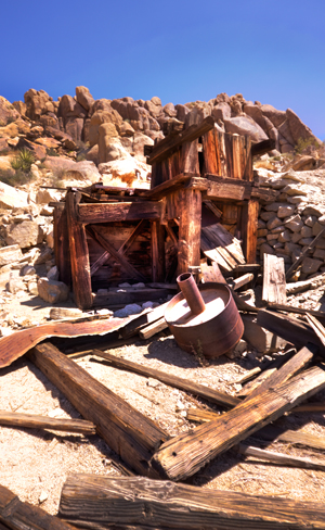
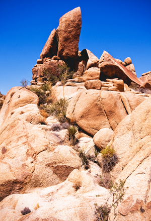
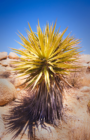
Left: Abandon gold mines remind us how cruel this place can be. Middle: Giant boulders make the trek risky and dangerous. Right: The foliage one sees on the trail is beautiful.
As we leave the cool comfort of the Oasis, the bright sun stabs our eyes. Even with dark sunglasses we are forced to squint. Hard sand, boulders and sparse vegetation greet us. A different world presents itself completely and so suddenly, it really is like night and day. We press on. After just a few minutes of climbing and descending, we can no longer see the Oasis. We’ve completed the first phase of the hike unscathed.
In the desert, hiking is not always on a noticeable path, so we are constantly checking the map and relying on small boulder markers to lead us in the right direction. We eventually come to a signpost that offers us two options: turn left towards the Mastodon Peak, or right to the Lost Palms Oasis trail, a 13 kilometre hike we definitely do not want to attempt today.
So we veer left.
The Oasis is at 899 metres in elevation, and we are climbing to 1,020 metres to get to the peak. The heat is like standing in front of a blast furnace. The wind is hot, not cooling. As a matter of fact, I think the wind makes the heat worse. My camera pack feels like a ton; my back is a sheet of sweat; my brows are dripping; and my arms are shiny with perspiration as my body struggles to cool itself. Every five or six minutes we need to take a break to catch our breath and hydrate. The cold water we bought at the start is now hot, and even though not refreshing, we know it is necessary.
Ahead, we can see our target — the peak.
We are forced to do a combination of climbing and hiking to reach a plateau near the peak where we find the remains of the old gold mine. The deep shaft has been covered over for safety purposes, but this stop features a great view of the desert, the ruin of the mine itself, some mining artefacts, and some much needed shade. From here we can see the Oasis and the majestic Eagle Mountains and our sightlines extend all the way from Mt. San Jacinto above Palm Springs to the Salton Sea. Formidable rock formations surround us — the boulders seemingly cracked by God himself.
My wife remarks that this “looks like cowboy country from a Hollywood movie.” We would not have been surprised if John Wayne came riding over the hill on his trusty steed.
After a 10 minute break, we start heading back — the downhill trek is much easier.
A kilometre down the trail from the mine we come upon what is left of Winona, a sad collection of concrete foundations which remain to mark the former mill and associated living quarters. This dusty outpost was home to workers from the Mastodon Mine, as well as workers at the mill, which processed ore from a number of other nearby mines. However we’re weary, hot and just about done. We don’t stop to look closer at what Winona might offer.
Descending past the ruins we follow the trail as it winds through various types of topography and cacti — again, very beautiful in a rugged, dangerous sort of way. As we progress, the terrain gets more level and easier to traverse. As we descend a small hill and round its corner, we see that we are back on level ground and coming up to the trailhead parking lot.
We finish the trail hike and almost all of our water at the very same time.
We get back to the car, open the windows a crack and turn on the A/C. While the pizza oven that is our car cools down, we review the hike, remembering how beautiful and yet how unforgiving it could be.
The cool air blowing from the vents and the thoughts of what we’ve just accomplished, bring a smile to our faces — Ranger Smiley would be proud.
About the Author

From tracking and naming a female Humpback Whale in Moorea, near Tahiti; in a hot air balloon adventure over the Napa wine valley, to visiting a native community two hours by canoe into the depths of the Ecuadorian Amazon, Mark has brought many adventure travel stories and images to readers across the country. A freelance contributor to TraveLife magazine, Mark also is a regular contributor of travel features to ExtraOrdinary Health Canada Magazine; and has been published in the Toronto Star, the National Post, and Air Canada’s EnRoute magazine, and in Photographer’s Forum: Best of Photography. Mark studied photography at Toronto’s Ryerson University. Mark’s been fortunate enough to travel to places many people dream of in addition to those mentioned previously; The Galapagos islands, Bora Bora, Taha’a, Raiatea, Costa Rica, extensively through the Caribbean, Puerto Rico, Mexico, Florida, California, Alberta, B.C., England and Scotland. Favorite spot? That’s a hard one – there have been so many but at the end of the day it’s no contest: Bucket list Bora Bora.